KYTC Unmanned Aircraft System (UAS) Pilot Training
Please note: This course is currently only available for employees of the Kentucky Transportation Cabinet. If you do not work for the Cabinet but are interested, you may complete the form and we will contact you if this course becomes accessible to a wider audience.
The use of drones, also known as Unmanned Aerial or Aircraft Systems (UAS), among state Departments of Transportation has grown significantly, from 45% of states in 2018 to 72% in 2019, according to a May 2019 survey by the American Association of State Highway and Transportation Officials (AASHTO). The types of missions and research conducted by states varies widely. AASHTO's survey finds that the top five drone missions in order of frequency are:
- Photo and video gathering of infrastructure projects
- Surveying and mapping
- Inspecting infrastructure, including bridges, signage, light poles, and pavement
- Responding to emergencies and natural disasters
- Public education and outreach

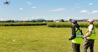
This two-day Unmanned Aircraft System (UAS/Drone) Pilot Training course prepares Kentucky drone pilots to conscientiously apply drone technology in support of KYTC responsibilities and (when authorized) those of KYTC partners. Attendees will receive a combination of classroom instruction and guided flight training. The course is held at a location with overhead clearance to allow for ample demonstration and practice.
Currently, this course is being scheduled by interest. Complete the form below if you are interested in participating in this course.
Overview
- Initial Hands-on UAS Training
- Part 107 Overview & Certification Guidance
- Introduction to Your New UAS Equipment
- How to Setup and Execute a UAS Project
- How to Use Trimble Stratus Mapping Software
- Final Hands-On UAS Training
The training will be held in two parts. Each part will take place from 8:30am to 4:30pm. Lunch and materials will be provided.
Use Cases for KYTC
Construction
- Pre-construction
- Environmental studies
- Project milestones
- Periodic As-Built updates
- Erosion control
- Lane closures
Design
- Current high resolution maps (up to 1/4 inch)
- Current Point Cloud (versus state LiDAR)
Traffic Operations
- Traffic pattern studies
- High resolution maps
Maintenance
- Inspections (equipment IDs, high mast light poles)
- Bridge inspections
- Rockslides & landslides
- Roadway condition assessments
Incident Management Coordination
- Remote inspection
- Traffic queue monitoring
- Covid-19 site observation
- Live streaming data to vested parties or command center
If you perform any of these duties, or have other possible use cases for drones within KYTC, you may be interested in and eligible for this course.

Location
UAS Training is held in Somerset at a location to be determined to allow ample space for demonstrations and pilot practice.
Instructors
Kentucky Transportation Cabinet
Division of Structural Design
Geotechnical Branch
1236 Wilkinson Blvd
Frankfort, KY 40601
|
Justin Wilson, PE |
Luke Turner |
Prerequisites
It is recommended that participants of this training complete one of the following AASHTO Technical Training Solutions (previously TC3) as a prerequisite to this course. KYTC employees may access these courses free of charge via MyPurpose. Local government agencies may access these courses free of charge with a promotional code. Contact Brittany Cloyd to obtain the current local government discount code for Technical Training Solutions courses.
TC3 Introduction to Unmanned Aerial Vehicles (UAS) for Highway Transportation
This training course introduces the applications of unmanned aerial systems (UAS) for a variety of projects within highway transportation planning and construction. As part of this training, participants will learn about the types and features of UAS, the legal and regulatory considerations around operating UAS in the field, how to determine if UAS technology is the appropriate application for the project need, as well as participate in general activities to prepare and utilize UAS in the field. Note: This course is not intended to prepare for the FAA Part 107 licensing preparations. It will, however, be a good starting point for those interested in pursuing licensure in support of their role at their transportation agency. This course offers professional development hours (PDHs).
AASHTO Store Link for UAS for Highway Transportation
TC3 Application of Unmanned Aerial Vehicles (UAS) for Bridge Inspections
What if you could generate high-resolution images and videos of any bridge surface while keeping inspectors and crew out of potentially dangerous locations? Well, you can. Unmanned aerial systems, or UAS, are changing the way we do bridge inspections. More and more engineers are choosing UAS over traditional methods like bucket trucks or snooper cranes - and it's easy to see why. UAS inspections save time, money, and lower risk. This course covers a range of topics related to UAS and bridge inspections. Module 1 will provide an overview of UAS and the challenges related to bridge inspection and management. Module 2 will walk you through the benefits of UAS for bridge inspections, and Module 3 will outline current trends and considerations you need to be aware of. Finally, Module 4 will provide examples of real bridge inspections that have used UAS technology. Note that this course will not prepare you for the Federal Aviation Administration (FAA) Part 107 licensing exam.
Interested?
Interested in taking this UAS Training Course? Complete the Google Form and once reviewed, we will contact you about your eligibility and scheduling.
Please note: You may be placed on a waiting list and you will be notified once a spot becomes available.

